
|
 16th February 2011, 09:31 PM
|
#1 |
|
Member
Join Date: Aug 2008
Posts: 264
|
Thought this map could be of use to those who were interested in Filipino weapons, the different regions, and ethnic groups around the Philippines. Very insightful considering it is an older map of the sections and territories that can be relative to the various weapons of these groups.

Last edited by Dimasalang; 16th February 2011 at 09:53 PM. |

|

|
|
16th February 2011, 09:55 PM
|
#2 |
|
EAAF Staff
Join Date: Feb 2005
Location: Centerville, Kansas
Posts: 2,196
|
Dimasalang, A great map that will be of invaluable help to many of us here. Thank you very much for posting this.
Robert |
|
|
|
|
16th February 2011, 10:44 PM
|
#3 |
|
EAAF Staff
Join Date: Dec 2004
Location: Louisville, KY
Posts: 7,139
|
Nice scan, thank you! I must admit I took stuff like this for granted.

|
|
|
|
|
17th February 2011, 10:19 AM
|
#4 |
|
Member
Join Date: Oct 2008
Location: Manila, Phils.
Posts: 1,042
|
dimasalang, thanks for the map!
one can almost imagine the topography here. for instance in luzon (the northern and largest island), where it says 'igorot/ibanag' is the cordillera mountain range; the elongated black strip on the left on the other hand is the zambales mountain range; and where you have the two large black 'negrito' strips with 'pagans' in between is the sierra madre mountain range. and those three mountain ranges basically define luzon topography. in between will be mostly flatlands to slightly hilly terrain, occasionally dotted by relatively smaller volcanic mountains. thus to avoid getting colonized, many filipinos then simply retreated deep into the mountain ranges, where it was a logistical nightmare for any invading force to sustain a campaign. i also don't wonder why the central highlands of samar and leyte have no designation as to who lived there. perhaps it was because those mountain ranges were practically impenetrable (not to mention that the people are very war-like) ... |
|
|
|
|
17th February 2011, 10:38 AM
|
#5 | |
|
Member
Join Date: Aug 2008
Posts: 264
|
Thanks guys.
 Im sure this map will be used extensively for reference by us and others in the not so distant future. Im sure this map will be used extensively for reference by us and others in the not so distant future.Quote:
You know what, I just realized that the deep interiors of Samar and Leyte are blank on the map. HAHA I would bet that is why it is empty, due to the dangerous region and warlike people living there...no one dared at the time; or at least survived to tell who lived in those regions during that time. Home of the Pulajanes...Waray-Waray people isn't it? |
|
|
|
|
|
17th February 2011, 01:19 PM
|
#6 | |
|
Member
Join Date: Oct 2008
Location: Manila, Phils.
Posts: 1,042
|
Quote:
And on a related matter, it is believed that it was the same seafaring Warays of Samar that made those routine attacks in southern China in the 12th century (in 'The Visayan Raiders of China Coast, 1174-1190 AD' by Efren Isorena, Phil. Quarterly of Culture & Society, June 2004). Back to the more recent past, what's that US Marines unit again (early 1900s, and related to the Balangiga encounter) which suffered deaths while simply crossing those mountains of Samar on a patrol mission, due to the difficulties involved? |
|
|
|
|
|
17th February 2011, 02:41 PM
|
#7 |
|
Member
Join Date: Dec 2004
Location: Witness Protection Program
Posts: 1,730
|
actually, on the first edition of the map, it WAS marked. it was later removed so it wouldn't cause any mass hysteria.
Ye Original Map 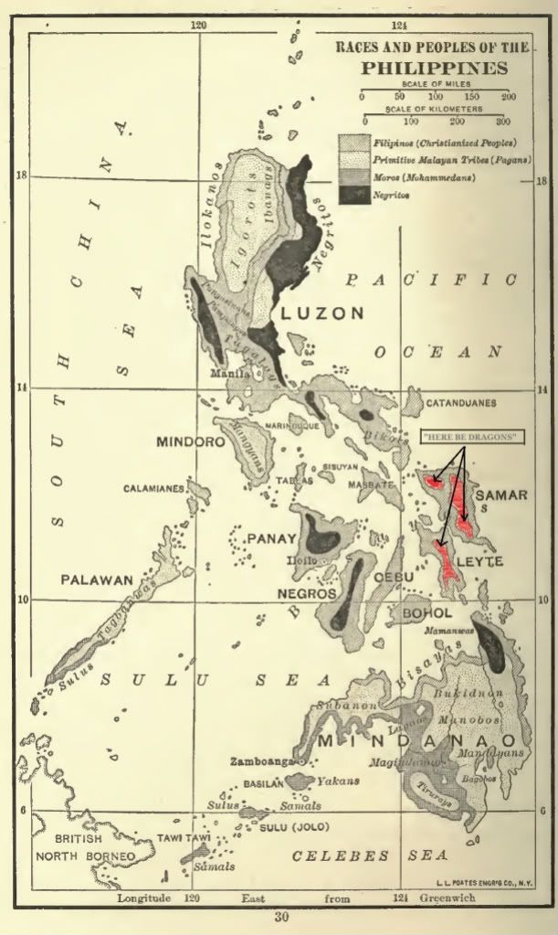
|
|
|
|
|
17th February 2011, 05:57 PM
|
#8 | |
|
Member
Join Date: Aug 2006
Posts: 608
|
Quote:
LoL... Someone had to give props where props were due... too funny.Re: the map, it seems to resonate with any/every anthro class (read: both) I took. In that one static image, you can almost envision the waves of migration of different peoples over millennia, with each successive "invader" more often than not pushing the previously settled people further from the coast. At a glance, based on the map it would appear as if the (Austronesian?) Igorot were the original inhabitants, followed by Negrito migrations (from PNG or Melanesia?), followed by the comparably "recent" migrations from elsewhere in SE Asia. Is this even remotely accurate? |
|
|
|
|
|
17th February 2011, 05:58 PM
|
#9 | ||
|
Member
Join Date: Aug 2008
Posts: 264
|
Quote:
 Quote:
I am guessing there was a lot of Dragon slaying as well, since the Dragons were also pushed to the highlands of Samar/Leyte.
Last edited by Dimasalang; 17th February 2011 at 06:17 PM. |
||
|
|
|
|
17th February 2011, 07:06 PM
|
#10 | ||
|
Member
Join Date: Aug 2008
Posts: 264
|
Quote:
Quote:
-Going way off on a tangent here..sorry- Waller was actually tried for executing in the town square his native guides from this expedition. During his trial is also where the controversial order by Gen Jacob Smith publically came out...to kill all natives over 10 years old and turn Samar in to a "howling wilderness"(retaliation and revenge for the Balangiga Massacre). Which became even a bigger stink in American papers and the US government...it fully eclipsed the Waller executions. Smith was quickly put to trial and was set to be charged; but after the trial he was given the choice to resign as Brigadier-General before facing sentence and a court-martial. Waller was also charged, but strangely enough was later acquitted. Waller(USMC) was being tried in a US Army court system. During that time, a court and trial of one military branch could not put to trial another soldier or officer of another branch. So automatically Wallers trial was considered void. Waller was never brought back to trial for the killing of these natives under the Naval court(Marines are under the Navy branch). Interesting being Waller was actually promoted to Colonel shortly after this controversy...I truly believe his promotion was due to this expedition and the respect the Marines had for this great accomplishment. The trek through Samar was the greatest expeditionary track of that era and made Waller a legend. Waller would go on to lead a very successful military career...fighting in WWI and ending his career with the rank of Major General. My brother, who was in the USMC, told me they mentioned this Samar expedition when they learned of Marine Corp lore and history during boot camp. http://en.wikipedia.org/wiki/Littleton_Waller You can read the basic overall story of Wallers expedition here. http://www.au.af.mil/au/awc/awcgate/usmchist/samar.txt |
||
|
|
|
|
17th February 2011, 11:10 PM
|
#11 | |
|
Member
Join Date: Oct 2008
Location: Manila, Phils.
Posts: 1,042
|
Quote:
that info is supposed to come out way till the end, on how the visayan hilt design really came about (see att.)  hey, how's everything? hey, how's everything?@dimasalang, thanks for the info on waller. that was very interesting. those sohoton cliffs in samar is surely one thing i have to add now to the places to visit before i die. what other books or reading would you recommend on the action in samar, during the phil-am war? thanks in advance! |
|
|
|
|
|
17th February 2011, 11:20 PM
|
#12 | |
|
Member
Join Date: Oct 2008
Location: Manila, Phils.
Posts: 1,042
|
Quote:
|
|
|
|
|
|
17th February 2011, 11:30 PM
|
#13 |
|
EAAF Staff
Join Date: Dec 2004
Location: Louisville, KY
Posts: 7,139
|
Good example of linguistics is the word "mata". In Hawaii and as far away as Easter Island, it means "eye". In Tagalog, "matari" means "fierce eyes". Interesting isn't it.
|
|
|
|
|
17th February 2011, 11:39 PM
|
#14 | |
|
Member
Join Date: Oct 2008
Location: Manila, Phils.
Posts: 1,042
|
Quote:
 here are other examples: here are other examples:parao - Tagalog (Phils.) folau - Polynesia barau - Efate farau - Tahiti volau - Fiji poruku - Futuna palahu - Indonesia prau - Indonesia broa - Formosa palwa - Tagalog (Phils.) bangka - Philippines wangka - Malay, Indonesia waka - Maori, Tonga, etc. vaka - Vaturana, Savo, etc. vaga - Alite va'a - Tahiti wa - Mate, Lamenu, Nul, etc. waha - Ceram wak - Numer paki - Fila wakten - Port Vato |
|
|
|
|
|
18th February 2011, 12:14 AM
|
#15 |
|
Member
Join Date: Aug 2007
Posts: 293
|
Hi, Dimasalang. Do you have the name of the person who made the map and the date it was made?
There are other similar ethnographic maps made before the colonization of the Philippines by the USA. Here are a couple of samples which I would like to add, thanks to the initiation of this thread by Dimasalang. One is attributed to Fernando Blummentrit, dated 1890. He was a respected ethnographer who wrote on the Philippines. Unfortunately, he had never visited the country  Another is by the Manila Observatory (made by locals under the supervision of Jesuit priest, Jose Algue), dated 1899. The map was turned over the Americans after the Spanish-American War. Thus, the details in the map are in Spanish, while the attribution (printed on the top left corner of the page) is "United States Coast and Geodetic Survey." An earlier map by Pedro Murillo y Velarde, dated 1734 is somewhat "ethnographic" as it contains images on both sides of the peoples and their customs - e.g. Bisayan, Aeta, Arabs, Chinese, Japanese, Mongol, Spaniard, Armenian, etc. It is always good to know the background of historical sources, in order to assess their value and limitations. The stories behind them are also interesting
|
|
|
|
|
18th February 2011, 06:21 AM
|
#16 | |
|
Member
Join Date: Aug 2007
Posts: 293
|
Quote:
The "out-of-Taiwan" theory of migration is popular and there are strong evidences supporting it. However, that is not the whole picture in my opinion. Surely there were migrations from elsewhere too, as proposed by other eminent scholars who have a differing opinion. In the study of weaponry, IMHO, the consideration of migrations while important has its severe limitations. Instead, the study of trading routes (instead of migratory routes) will provide more leads. I also would like to think out of the box and consider the possibility that "original" inhabitants were living in elevated areas (e.g. mountains) instead of the coast in order to avoid malaria. Thus, the push into the mountans may have happened only later - i.e. after people had already started living along the coasts in order to take advantage of trade. Before the period of trade, the inhabitants settled the mountains, not lowland coastal areas. I could be wrong though. |
|
|
|
|
|
18th February 2011, 05:17 PM
|
#17 | |
|
Member
Join Date: Aug 2007
Location: Germany, Dortmund
Posts: 8,491
|
Quote:
Last edited by Sajen; 18th February 2011 at 08:53 PM. |
|
|
|
|
|
19th February 2011, 12:03 AM
|
#18 |
|
EAAF Staff
Join Date: Dec 2004
Location: Louisville, KY
Posts: 7,139
|
Thanks Sajen. I wondered since Filipino languages, Indonesian and Malaysian languages are all related.
|
|
|
|
|
19th February 2011, 03:00 AM
|
#19 | |
|
Member
Join Date: Aug 2007
Location: Germany, Dortmund
Posts: 8,491
|
Quote:
Yes, all three are malay languages. Regards, Detlef |
|
|
|
|
|
19th February 2011, 03:56 AM
|
#20 |
|
Member
Join Date: Jan 2006
Posts: 123
|
I lived my Malaysia for two years....but I regret not having learned the language.
|
|
|
|
|
19th February 2011, 04:09 AM
|
#21 | |
|
Member
Join Date: Dec 2004
Location: Witness Protection Program
Posts: 1,730
|
Quote:
|
|
|
|
|
|
19th February 2011, 01:13 PM
|
#22 | |
|
Member
Join Date: Oct 2008
Location: Manila, Phils.
Posts: 1,042
|
Quote:
yep they were here. and we had lunch with nacho & reichsritter. among other activities we surveyed the 1904 st. louis expo sandata that are now at the phil. national museum (pic attached). |
|
|
|
|
|
19th February 2011, 01:54 PM
|
#23 |
|
Member
Join Date: Dec 2004
Location: Witness Protection Program
Posts: 1,730
|
nothing but good things about you guys, is what i heard... hopefully next year would be my turn. we're having a reunion at CPU, so checking out bandholtz collection is definitely in my to do list. would love to see the pre hispanic collection. but most of all, sisig and sarsi
|
|
|
|
|
20th February 2011, 02:20 PM
|
#24 | |
|
Member
Join Date: Oct 2008
Location: Manila, Phils.
Posts: 1,042
|
Quote:
... then on to the sisig and sari en route to the museums
|
|
|
|
|
 |
|
|


 Linear Mode

